Gonzalo Sanz Segovia | 06/11/2025
The silhouette of Chile is one of the most recognizable on the world map. This elongated and narrow country, nestled between the Andes mountain range and the Pacific Ocean, is a true maritime balcony. Valparaíso, one of its most iconic cities, reflects both its beauty and the natural risks faced by the region, located in the Pacific Ring of Fire.
The Republic of Chile, which borders Peru, Bolivia, and Argentina, is an abrupt territory, traversed by the imposing Andes mountain range. Its geography is heterogeneous: it houses desert areas, mountainous regions, steppes, and even polar landscapes. Extreme climates and constant threats coexist, as it’s a seismically active region, with numerous latent volcanoes. Its extensive port network makes it a strategic country for Latin America, and it has signed multiple free trade agreements with countries such as Canada, the United States, China, or Australia, as well as with its neighboring countries, like the recent agreement reached with Argentina during the International Congress of Enloce 2025 held in Valparaíso.
According to the Ministry of Foreign Affairs of Spain, Chile is a country where natural disasters, especially earthquakes, occur with notable frequency and can have highly destructive effects. The last earthquake of a considerable magnitude was recorded in August of 2024, affecting Antarctic zones and triggering the activation of all emergency protocols.
Detection and early reaction
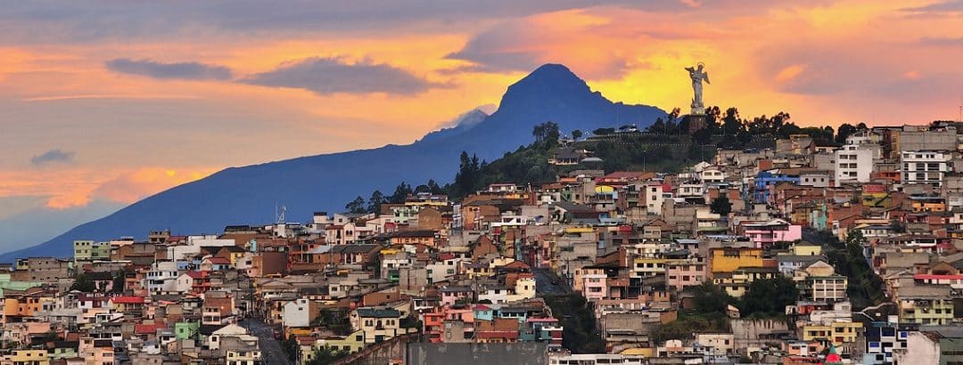
The vibrant port city of Valparaíso, located in central Chile, has a traditional urban feel to it, which stems from its having to adapt to the hills surrounding it, and its historic district was declared a World Heritage Site more than 20 years ago. Its natural enclave, its location over active faults, and its sloping descent to the sea make it especially prone to fires, earthquakes, and tsunamis, a context that’s tackled head on with a robust prevention and response system aimed at ensuring the safety of its people.
Although the country has been making progress in forecasting events, articulated by national organizations, it was deemed necessary to create a permanent regional body to coordinate disaster prevention, preparedness and mitigation actions, outlined in the National Strategic Plan for Disaster Risk Management (2018-2030), published by the National Disaster Prevention and Response Service (SENAPRED). It outlines the main natural hazards to which Valparaíso is exposed, among which are:
- Earthquakes and tsunamis along the continental and insular coastal edge.
- Forest fires.
The Regional Management of Valparaíso proposed making risk reduction a local priority with a solid institutional base, with the aim of strengthening monitoring and early warning systems, promoting a culture of prevention and insurance among the city’s people, and reinforcing disaster preparedness to ensure an effective response.
The sea: support and warning
Throughout its history, Chile has suffered devastating tsunamis, such as the one generated by the Valdivia earthquake in 1960, the most devastating catastrophe experienced to date in the region. According to SENAPRED, Valparaíso is on constant alert to the possibility of major earthquakes and tsunamis, which demands preventive measures and agile citizen coordination. To address these risks, the province has implemented a series of measures that strengthen the city’s ability to protect its inhabitants. One of the main advances has been to establish routes and evacuation plans, designed to reach safe areas in case of emergency.
One of the most important organizations active in implementing emergency protocols is the Hydrographic and Oceanographic Service of the Chilean Navy (SHOA), responsible for monitoring the behavior of ocean soil and tides, as well as issuing alerts in the event of a tsunami. Together with SENAPRED, it coordinates monitoring, forecasting, sending of alerts, alarm, and emergency extinguishing. Specific measures are activated in each phase, from preventive evacuation to deployment of troops in affected areas.
In Valparaíso, more than 116,000 people live in vulnerable areas, according to the Tsunami Flood Maps (CITSU) prepared by SHOA. In case of a threat, and according to the assessments carried out by the National Marmote Alert System (SNAM), a warning is issued to the public via official channels, and the National Emergency Alert System sends text messages to all users who are in the risk zone. In addition, information campaigns and drills are carried out in collaboration with schools, municipalities, and emergency services on a regular basis to promote a collective awareness of prevention and, in turn, evaluate the effectiveness of the protocols established in the region.
The latent threat of fires
The geographic and climate conditions of Valparaíso make it prone to fires, because of longer dry seasons and the high presence of pirogen exotic vegetation. An example of this is the great fire that ravaged the province in 2024, which left 135 fatalities and more than 11,000 hectares burned, mostly forest forests (53%) and abusive pasture (39%).
Urban idiosyncrasies have hindered Valparaíso’s ongoing development and management in a number of ways. Its abrupt and uneven extension, coupled with a scarcity of water resources in peri-urban areas, hinder containment and control efforts when a fire breaks out, which means the flames can spread rapidly and damage homes and critical infrastructure.
To address this complicated situation, the Regional Forest Fire Emergency Plan established a scale of priorities to protect, first and foremost, people and populated centers, followed by national parks, biodiversity reserves, and forest spaces.
In extreme cases, when local capabilities (forest rangers (CONAF) or the fire departments) are overwhelmed, they coordinate with SINAPRED, which quickly provides regional, national, and even international resources if the emergency requires it. y According to the National Policy for Disaster Risk Reduction, it’s imperative to strengthen existing capacities and develop new ones, with the aim of making Chile a resilient region in the face of this new climate reality.